“BURATAMORI” is one of the most popular and long-run TV series of NHK (Japan Broadcasting Corporation) in Japan.
You can be healed just by watching and study the show.
It is a program where people can re-discover new charm and culture of cities while encountering their history, secret stories, and traces left on the terrain of the lands in the cities.
One day, when we have a chance to visit the places introduced in the show, we will read back the records of BURATAMORI in advance so that we can enjoy the trip much more.
So, before I forget the contents of the TV program, I would like to write the focal points as our memorandum in this blog.
- Why did the Satsuma Clan become the leading role in the Meiji Restoration?
- Castle and town planning by the Shimazu Clan
- Why does Shiroyama have cliffs and plateaus?
- Whole Kagoshima was a fortress.
- Let’s look at Kagoshima’s town planning and castle town.
- Many heroes were produced from Kajiya-Cho town.
- The secrets of the Satsuma Clan and how they used different stones.
- The Satsuma Clan used various stones for different purposes.
Why did the Satsuma Clan become the leading role in the Meiji Restoration?
Many heroes emerged from Kagoshima far from Edo and Kyoto and involved in the Meiji Restoration. This is largely related to Kagoshima’s unique terrain and town development.
The Satsuma feudal lord, the Shimazu, who ruled Kagoshima for more than 700 years, had accumulated enough power to compete with the Edo Shogunate at the end of the Edo period, despite losing to Tokugawa Ieyasu in the Battle of Sekigahara.
However, at the end of the Tokugawa period, they were as powerful as the Edo Shogunate. Why was the Shimazu Clan able to accumulate such great power?
Castle and town planning by the Shimazu Clan
The driving force behind the Meiji Restoration can be seen in the “town development” that the Shimadzu family performed in Kagoshima during the Edo period.
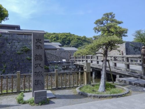
From the ruins of Tsurumaru Castle, a typical castle in Kagoshima, you can see what triggered Satsuma to grow.
The ruins of Tsurumaru Castle are located in the center of Kagoshima City, a short distance from Kagoshima Station to Kagoshima Chuo Station. Tsurumaru Castle was built in 1602 after the battle of Sekigahara.
The moat is only 13m wide and only 80cm deep, and you can still see the stone wall very close to the sidewalk.
There are many bullet marks on the stone wall near the castle entrance. Many of these are traces of bullets from the army revolt, the Seinan War, which took place in 1877 with Takamori Saigo as their leader.
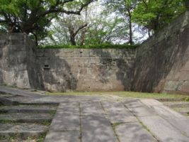
The height of the stone wall is as low as 6.6 m, and the width, depth, and height of the moat are only about one-third of those of Kumamoto Castle.
And just 60m from the moat, you will reach the “Honmaru” or the main enclosure of a castle. Tsurumaru Castle does not have a castle tower, so it looks very vulnerable.
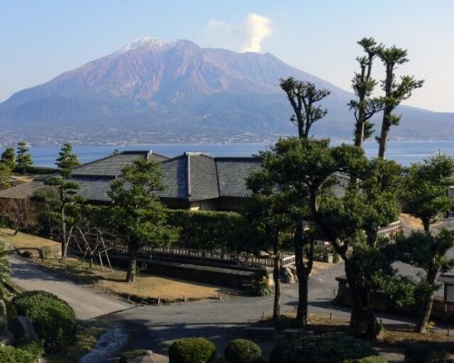
The importance of “Shiroyama” mountain
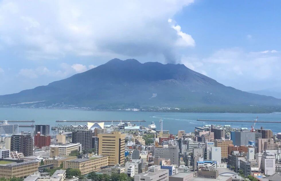
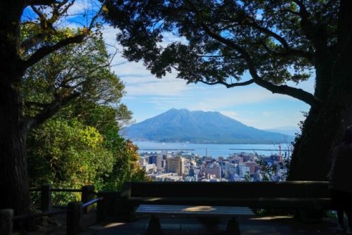
Tsurumaru Castle was safe even if it was unprotected because of the 108m-high “Shiroyama” mountain with a cliff behind the “Honmaru” of the castle.
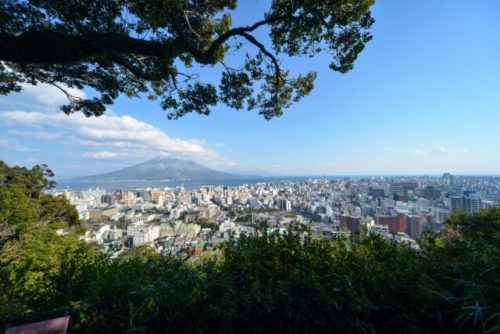
When you climb Shiroyama mountain, you can see the “Sakurajima” island from above. It is a flat plateau.
A flat place in the mountains was called “Kuruwa,” which was a place where soldiers were stationed during a battle to secure their defenses.
There are five “Kuruwa” in Shiroyama mountain. Tsurumaru Castle was safe without a defense because Tsurumaru Castle was built under cliffs and slopes of Shiroyama mountain.
Accordingly, the true guardian key of Tsurumaru Castle was Shiroyama mountain.
Why does Shiroyama have cliffs and plateaus?
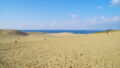
What is “The Shirasu” plateau?
“The Shirasu” plateau is a unique stratum that spreads around Kagoshima Prefecture. Shirasu plateau is a collection of pyroclastic flows of high-temperature volcanic ash, pumice, and water vapor erupting from volcanoes.
Shirasu observed in Shiroyama was not created by the eruption of Sakurajima, but by pyroclastic flows came down from the Aira Caldera.
A caldera is a huge hole made by the sinking of the entire mountain due to the eruption of a volcano and the disappearance of underground magma.
It is said there was a huge volcano named the “Aira Volcano” on the north side of Sakurajima about 29,000 years ago.
How was the Shirasu plateau made?
The layer that covered the plateau which was compacted by heat and pressure is called the Shirasu plateau. In some places, the thickness of the Shirasu is as much as 100m.
It is said that Sakurajima was born by volcanic activity about 3000 years after the eruption of Aira volcano, and has become the current topography.
The characteristic of Shirasu is that the surface is brittle and easily collapses. Immediately after the eruption of the Aira Volcano, the area became flat and covered with white Shirasu.
After that, a groove that was eroded by rain was formed, and the surface of the groove became fragile and eroded vertically over a long period, and a cut slope was completed.
And the top of Shirasu that was not eroded by rain remained flat. As a result, the Shirasu plateau seen in Shiroyama was completed.
Whole Kagoshima was a fortress.
More than 50% of Kagoshima Prefecture is made up of the Shirasu Plateau. Taking advantage of the characteristics of this Shirasu plateau, many fortresses were created at the foot of the Shirasu plateau in Kagoshima Prefecture, just like Tsurumaru Castle.
In other words, the whole Kagoshima was functioning as a huge castle. That’s why Tsurumaru Castle, in the center of the castle, was safe even without defense.
Another reason Tsurumaru Castle was created under Shiroyama was the spring water from Shiroyama. The Shiroyama stratum before the deposition of Shirasu was “mudstone” and it was impervious to water.
Shirasu, on the other hand, has the characteristic of absorbing water and passing a certain amount of water down little by little.
Therefore, a certain amount of spring water flows from the boundary between mudstone and Shirasu.
Water is indispensable for a castle. In this way, the castle was created by taking advantage of the characteristics and terrain of Shirasu.
Let’s look at Kagoshima’s town planning and castle town.
The secrets of the castle town – the track
Take a tram running through Kagoshima city to see the secrets of the castle town. The clue of the secret lies on the track.
The line train that connects Izurori from Kagoshima station square has almost no straight line and the track is curved.
This was once a track along the coastline, as can be seen from the stone lanterns in Izuri Dori (formerly acted as the lighthouse of the ship).
The seaside from this track was reclaimed by the Shimazu Clan, and trade with China expanded through the Ryukyu by allowing traders to live there.
This was the country and town planning that the Shimazu Clan aimed for., which allowed the clan to save a lot in foreign trade, despite the turmoil at the end of the Tokugawa period.
It is said that the sum was equivalent to three years of the clan’s income.
Tenmonkan, the station next to Izuro-Dori, is the largest downtown and entertainment district in southern Kyushu.
An ingenious attempt to create a castle town.
This area is not a landfill, but an original area. And here you can also see an ingenious attempt to create a castle town.
Samurai used to live in this area. At present, when you walk in this downtown area, you would notice that there are places where the ground is higher.
This rise was traces of the Kotsuki River, which had originally flowed here. And the Shimazu Clan artificially changed the flow of the Kotsuki River and diverted it. And they newly developed the river so that samurai warriors were able to live in this landless area.
At that time, 25% of the population of the Satsuma Clan was samurai warriors. So this kind of river replacement was performed to gather many samurai in one place.
As a result, this castle town became a major samurai residence where 50,000 samurai lived and had great influence at the end of the Tokugawa period.
Many heroes were produced from Kajiya-Cho town.
There is a place called “Kajiya-Cho” or Kajiya Town along the Kotsu River that was replaced.
There is a place in Kajiya-Cho where you can experience the history of Satsuma. The place is called “Ishin Hometown Road” or Home town of Revitalization Road. There is also a place of Takamori Saigo’s birth nearby.
Just 150 meters away, there is a birthplace of Toshimichi Okubo. Many other Meiji Restoration heroes such as Heihachiro Togo, Shinpachi Murata, Iwao Oyama, Kuniki Shinohara, and Tomomi Yoshii, are also from Kajiya Town.
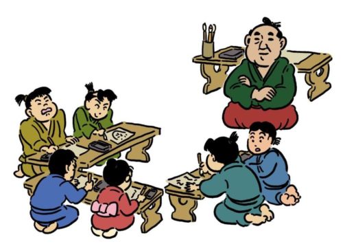
This was because of Kagoshima’s unique education system in those days.
The education system at that time was called “Gochu Education” and youth provided education to children to learn studies and martial arts in each region.
Among them, Takamori Saigo and Toshimichi Okubo were both young leaders in the Kajiya-Cho area.
Kajiya-Cho was a valuable place where the younger generation was able to directly learn from the two heroes of the Meiji Restoration.
Creating castles and towns using the topography of the Shirasu Plateau. Raising funds and strengthening finances through trade with China. And developing human resources through the unique educational system.
All these factors were the major factors that enabled Kagoshima to take the lead during the Meiji Restoration.
The secrets of the Satsuma Clan and how they used different stones.
Make “Daiba” preparing for attacks from overseas
Heading toward the sea from Tsurumaru Castle. Then you will see the “Daiba Ruins” where you can see the stone walls that used to carry cannons.
There is also “Daiba” or a battery in the Edo period in the wake of Perry’s arrival (so-called Kurofune, the great Black Ship) in 1853. But Daiba in Kagoshima was built in the earlier 1940s.
Many years before the Kurofune came to Japan, the Satsuma Domain had already been preparing for an attack from a foreign ship.
At that time, the most likely route used by European and Western powers to attack Japan was the route coming into Japan from the Chinese side.
In that case, Kagoshima is located as a place that would likely be the first choice in Japan to be attacked by enemies.
Mining was easily done due to the characteristics of “Tantado Stone.”
Therefore, the Satsuma Domain had been preparing for defense in this area more than 30 years before Perry’s arrival. This Daiba is made up of stones called “Tantado Stone.”
There is a bus stop called “Tantado” about 3km northwest from the site of Daiba.
This area has long been a quarry. It is a place where stones are cut from the mountain and processed.
The stratum here is a stratum in which 29,000 years old “Shirasu” or post-larvae was deposited on welded tuff (ignimbrites). They formed about 500,000 years ago.
The flow of the river has cut Shirasu over time, exposing this welded tuff.
Welded tuff is a rock that is formed by melting a pyroclastic flow with high heat and high pressure.
There are various types, but the welded tuff that can be obtained in this area is called “Tantado Stone.”
The characteristics of “Tantado Stone” is that it has many vertical cracks. These cracks are formed when the lava cools down and hardens. They are called “Chujosetsuri.”
Owing to these cracks, “Tantado Stone” is easy to dig from mountains and stones can be easily machined. The Satsuma Clan has developed its clan using the “Tantado Stone” not only for “Daiba” or a battery construction but also for various purposes.
Nariakira Shimazu, the driving force behind the modernization of the Satsuma Domain
Nariakira Shimazu, the 28th head of the Satsuma Domain, was the driving force behind modernization.
The stage for the modernization was called Senganen, a private residence of the Shimadzu clan. The place was located about 3 km northeast of the quarry of the “Tantado Stone.”
The scenery overlooking the garden from the audience room at Sengonen garden is very beautiful.
There is a stone lantern in the garden, and Shimazu Nakiaki was experimenting with gas lamps using this stone lantern.
Yokohama comes to mind for many people when it comes to gas lamps. But fifteen years before Meiji 5 when gas lamps were born in Yokohama, Nariakira had already made gas lamps in this garden.
In the garden, a place that was originally a bamboo grove was cut open, and stones were piled up to create a ” reverberating furnace.”
The reverberating furnace is a metal smelting furnace for the refining iron invented in Europe in the 18th and 19th centuries.
Nariakira built this reverberating furnace in the garden, melted and refined iron to make a cannon.
Going further west from Sengonen, you will find a 77m long building built during the Edo period.
Currently, it is a museum, but at the end of the Edo period, it was a machine factory. The exterior walls of this building also utilize unique Satsuma ingenuity.
“Onoishi” used for the outer wall
The outer wall is made of stone called “Onoishi”. Onoishi is a stone that can be mined in Ono-cho town, 10 km away from Sengonen garden.
Why was Onoishi stone used instead of Tantanite? This is because Onoishi stone has a thermal insulation effect, cool in summer and warm in winter, suitable for machine shops.
There are several calderas in Kagoshima, and different types of pyroclastic flows were blown out in each era.
Therefore, there are several different types of welded tuffs even near the place, and there are as many as 20 types.
Welded tuff called “Yamakawa Stone” has a feeling that it sticks when the surface is put on the tongue and released slowly.
This phenomenon is called capillarity because there are many small gaps on the stone surface.
Yamakawa stone is hardly weathered because it is not easily affected by temperature changes due to these many gaps and does not expand or contract.
The Satsuma Clan used this Yamakawa stone as a stone for a grave. Shimazu’s grave is also made of this Yamakawa stone.
The Satsuma Clan used various stones for different purposes.
In the garden, not only the reverberatory furnace but also a glass factory and a smelter were built. Nariakira named these places, “Shuseikan.”
There was a mountain behind the Shuseikan, and it was an environment where water could be dropped from a high place.
Nariakira saw the opportunity and turned the windmill by the hydraulic power falling from there, using the power to pierce the cannon.
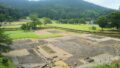
Upstream of the waterway leading to Shuseikan or the machine factory, about 4 km north, there is a rice field that spreads around the waterway.
Let’s go to the start point of the waterway. Looking at the geological map, a place surrounded by welded tuff in Kagoshima is only this place and very rare.
The people of Satsuma built a waterway using this easy-to-process geology. Nariakira utilized this waterway as industrial water and used it for modernization.
Utilization of miraculous land due to the topography and geology of Kagoshima
If this area was the Shirasu plateau, a waterway could not have been created.
This place may be a miracle land being surrounded by welded tuff and being able to process rocks to create a waterway.
What is most amazing above all is that Shimazu, the head of the Satsuma Clan, was well-familiar with the topography and geology of Kagoshima.
Shimazu Naoki did not miss opportunities to lie in this miraculous place.
The Satsuma Clan achieved the modernization of Kagoshima and the Meiji Restoration by utilizing various types of pyroclastic-flow deposits for different purposes.